


Exclusive: Technology Boosts Opportunities for Surveying Equipment Dealers
As the lines blur between surveying and GIS, dealers can strategically reposition into both service and product sellers.
By Don Talend
“Bob” is a fictitious project manager for Urban City, USA—and he has a problem that just begs to be solved. The mayor has tasked Bob to complete two missions. First, Bob needs to create survey plats for all of the municipal parks in Urban City. Secondly, the mayor wants a comprehensive geographic city map of all streets and several municipal assets—light poles, fire hydrants, drainage inlets and sewer manholes.
If Bob had posed his problem to the inside sales rep at his local survey dealer just two or three years ago, he probably would have been told, “Sorry, Bob. We do not offer surveying or GIS services. We only sell survey instruments.”
But today, Bob might get an answer like, “Yes, we can definitely help you with that task. We own a mobile mapping system and we can actually collect the data you need. Tell me a little more about the scope and requirements for your project. I will get our mobile mapping specialist to work up a quote for you. We would also be glad to provide a demo of our equipment for the surveying work that you are planning.”
 |
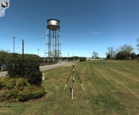
| Earl Dudley, Inc. mounted a Topcon IP-S2 mobile mapping system onto an SUV. The geospatial equipment dealer has diversified by providing data-collection services with the aid of the IP-S2. |
The business model is changing for surveying equipment dealers who have invested in Topcon Positioning Systems’ (TPS) IP-S2 3D mobile mapping system. Such advances in technology allow the fictitious dealer above to sell services in addition to products.
Mobile mapping systems are revolutionizing the way we collect data. The current methodology is based on collecting discrete points for specific features. The surveyor uses a total station or GNSS rover. The GIS technician uses a GNSS data collector. But the concept is the same: Collect only the specific information we are interested in at the present time.
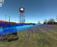
Data collection with a mobile mapping system works on the reverse principle—collect all of the available information, then extract or “mine” only those data in which we are interested. But mobile mapping is about more than an exponential increase from hundreds of discrete data points to the millions of points that can be collected by laser scanners. Mobile mapping provides comprehensive information, a virtual 3D reality that not only provides information about specific features but also the surrounding setting and context. The IP-S2 merges spherical camera images with colorized point clouds. From the computer screen, an operator can visually get “inside” the area and view it from a 360-degree perspective.
 |
| A Topcon GR-5 receiver from Earl Dudley, Inc., is set up to collect GNSS data for post-processing into a geographic information system file. |
Real-life adoptive dealers
Dealer adoption of IP-S2 mobile mapping technology is not merely fictitious. Across North America, several TPS dealers have invested in it. The list includes The PPI Group, Portland, Ore.; Boyd Instruments, Horsham, Pa.; Caron East Inc., Cumberland, Md.; Earl Dudley Inc., Birmingham, Ala.; GeoShack, Dallas; Positioning Solutions Company, Carol Stream, Ill.; and Brandt Tractor, Calgary, Alberta, Canada.
A closer look at the experience of one of these dealers reveals how a typical evolution of the dealer / service provider business model develops.
Earl Dudley, Inc., was founded in 1938 as a survey instrument repair shop and has expanded over the years to operate dealerships in Charlotte, N.C.; Duluth, Ga.; Nashville, Tenn., and Jackson, Miss. As technology evolved, the company also expanded into equipment sales and application consulting. The key to Earl Dudley’s business success started with a thorough knowledge of the attributes of each product sold, whether it was a sophisticated total station or a simple level rod. It included a working knowledge of surveying objectives and techniques. Couple these with a sincere interest in the customer’s intended goal. The result is the right product for the right application for each customer.
 |
| Point cloud data from photo of water tank, which will be utilized by the City of Demopolis, Ala., as a new water tank and supply lines are constructed there. |
Over the years, the company expanded into other products from TPS’ diverse lines of precision positioning equipment—GNSS systems, machine control, construction lasers and precision agriculture systems. The addition of each new product required a new business plan and hiring and training staff to maintain the company’s principal objectives.
Earl Dudley’s recent venture into mobile mapping brought myriad new opportunities. In March 2011, the company invested in an IP-S2 mobile mapping system. From the start, their intention was clear: use the system for demonstrations to potential purchasers, but also provide data collection services. Management understood that some customers want to utilize dynamic 3D mobile mapping data but may not have immediate purchase plans.
The dynamic 3D data produced by a mobile mapping system is in itself an extremely desirable commodity. The daily worldwide use of geographic data and street-view imagery produced by major Internet mapping providers has raised the expectations of the general public, government agencies and professionals. When commercial consumers learn that they can have similar tools at their fingertips targeted to their specific business applications and geographic areas, they are motivated to spend money on the data processing services.
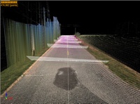 |
| Typical road cross-sections as viewed in Topcon ScanMaster software. |
As times change, successful companies grow by diversifying and creating new revenue streams. Providing mobile mapping services not only improves the financial bottom line at the end of the year, but it also offsets the initial cost of investment in the system.
Adam Arrington, vice president, is driving the mobile mapping business for Earl Dudley. “This is an exciting year for our company,” he said. “There is always risk when venturing into new technology. We spent nearly one year investigating the mobile mapping market and talking to customers. We are convinced that we made a sound decision.”
Service can lead to product sales
How does the dealer/service provider qualify a customer as a product sales prospect or service sales prospect? These two classifications are not necessarily mutually exclusive. Someone who contracts for data collection services might eventually purchase a system.
For example, Urban City has 825 miles of city streets. At 25 miles per hour, it would take 33 hours, or slightly more than four working days, to map the entire city. Adding an extra day for mission planning brings the total time expenditure to roughly a week. The public works department can remap the city once every six months to keep its database current. But how can Urban City justify purchasing a system that will be used for only two weeks out of each year? In this scenario, it would make sense for the city to pay for mapping services as needed.
In real life, Earl Dudley is already enjoying great success as a mapping services provider. The company has completed two paid projects, both perfectly suited for mobile mapping.
In one project, a GIS consultant contracted for data collection on a military facility in Marietta, Ga. The deliverables included a processed dataset and a copy of Topcon’s Spatial Factory software. Using these tools, the consultant will build an asset database and a 3D model for their military customer.
The second completed project was an engineering mission. The City of Demopolis, Ala., intends to install a new water tank and supply lines in an established neighborhood. A local engineering firm was engaged to perform a 3.2-mile pre-construction route survey. It will use LiDAR data collected with the IP-S2 to create cross-sections of existing terrain for design purposes. In addition, the firm will have a complete visual record of site conditions from the 360-degree spherical images. The mobile mapping team set up a Topcon GR-5 GNSS receiver onsite to enable post-processing of the IP-S2 data for high-accuracy results.
Four new projects are already on Earl Dudley’s schedule. The GIS consultant customer from the first project listed above wants to map four more military facilities in a nearby state. Two county governments in Georgia are paying for pilot asset inventory projects to determine the feasibility of using mobile mapping for countywide data collection. A town in Alabama wants 30 miles of data collected to map all utility poles and above-ground water installations. The major electric power provider in Georgia wants ground-level LiDAR to merge with existing aerial data. The list continues to grow.
In between projects, Earl Dudley is following through with the company’s philosophy of exploring every facet of a product they sell. Arrington is a licensed professional engineer and is extremely demanding when it comes to product performance. “We have completed numerous test runs and used different data processing techniques,” he said. “We want to understand exactly what level of accuracy we can deliver and the processes required to attain it.” Since data products are the primary deliverable of a service provider, the company is also creating workflows for formats such as cross-sections and contour maps.
There is a common thread among each of Earl Dudley’s projects. The client sees mobile mapping as a great improvement over conventional data collection methods and can also see the value proposition that systems like the IP-S2 offer. They do it faster, more safely, more efficiently and provide a higher level of accurate information.
“The IP-S2 system is another step in the evolution of the Earl Dudley business model: being first at providing solutions to our clients that allow them to expand their business and profitability,” Arrington said. “We really think that the IP-S2 is a good fit because it reaches out to a wide variety of applications for both GIS and engineering customers. It is providing us with new business opportunities that stimulate our growth and improve our survivability as an established company.”
Don Talend of Write Results Inc., West Dundee, Ill., is a print and e-communications provider specializing in covering technology and innovation.
Learn more at www.topconpositioning.com
CONTRACTOR SUPPLY MAGAZINE


The April/May 2026 issue of Contractor Supply magazine is here!
In our cover story, Precision Over Volume, Tool Factory Outlet of Goshen, New York is a contractor supply operation built on niche brands and technical expertise.
Take a look back at World of Concrete 2026. Also in this issue are Industry Updates.
This digital edition, sponsored by BECK AMERICA Inc., is fully searchable and contains live links to every advertiser and new product listing. Click away!
| Read the Articles Read the Digital Edition |