Professional Measurement: Topcon Hybrid Positioning System
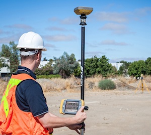 Topcon Positioning Group announces a new technology – Hybrid Positioning – that increases efficiencies and improves productivity on job sites, regardless of conditions, terrain or location. Hybrid Positioning is enabled through the Topcon MAGNET software suite, a Topcon enterprise solution for the geomatics industry.
The new Topcon technology allows precise positioning professionals in the survey, construction, civil engineering and GIS industries to simultaneously connect to GNSS signals and standard robotic measurements on a single rover pole.
Ewout Korpershoek, chief marketing officer of Topcon Positioning Group, said, “This extremely clever and unique combination of GNSS and optical measurement is aimed squarely at improving a company’s profitability by allowing the use of GNSS positioning and optical positioning data at the same time. When used with Topcon MAGNET software, Hybrid Positioning improves field measurement efficiency at every phase of a project.
“With Hybrid Positioning technology,” he said, “the key is versatility. For example, when line-of-sight is blocked, shots can be easily and quickly measured with the GNSS receiver. Now it is so easy to combine a standard Topcon robot and GNSS receiver to guarantee an integrated solution for the highest performance and productivity.
“Combine these two proven solutions, plus advanced MAGNET Field software, and you have Hybrid Positioning technology,” Korpershoek said. “By utilizing both GNSS and optical measurement, any project can be completed faster and with unsurpassed accuracy. By adding MAGNET cloud-connected data workflow, truly outstanding increases in productivity and cost savings are assured.”
The new technological breakthrough has four key components – Hybrid Lock, Hybrid Resection, Hybrid Switch and Auto-localization.
Hybrid Lock allows accurate prism tracking by simply turning the instrument toward the prism location. Hybrid Resection ensures quick job site setup, as well as establishing RTK and geodetic coordinates. Hybrid Switch ensures a quick changeover from GNSS to optical measurement with a single touch. Auto-localization utilizes Bing Maps background, multi-point localization and works with RTK and NMEA positioning.
Korpershoek said, “Regardless of job site location or adverse conditions or terrain, Hybrid Positioning systems will perform faster in the field than other instruments and with more versatility than an RTK-only system.”

