Professional Measurement: Topcon TopNET+ v10
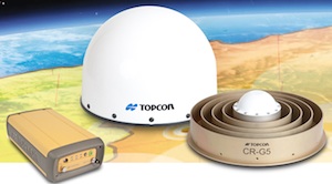 Topcon Positioning Group announces new reference station network software – TopNET+ v10 – bringing new features and functionality to the industry-leading TopNET+ reference station software suite.
Topcon’s TopNET+ software is a scalable solution supporting everything from a single CORS station to multiple CORS sites covering a large geographical area. Users of a TopNET+ reference network get GNSS RTK correction data generated using information from all reference stations in a network. This feature allows regional use of RTK while providing data that is specific for each local rover.
New features available in the latest TopNET+ v10 include:
- Custom sub-networks based on a rover’s position within a larger regional network, which better supports the network RTK rover to local field conditions;
- RINEX (Receiver Independent Exchange Format) shop with expanded data management functionality for conversion of data from Topcon and third party reference stations connected to the network;
- Background maps and BING™ Maps allow multiple perspectives of the network orientation and regional surroundings;
- Expanded network RTK engine logging providing detailed metrics of TopNET+ results.
Tom Morris, TPS senior product development manager, said, “This upgrade of TopNET+ software provides increased capabilities and a more visual and detailed presentation of network status to the users of Topcon networks. Users will have a customized solution better adapted to local conditions and a better view into the hard processing and statistics being generated in TopNET+.”

